
Scaling the Giant: How Big is Iran Compared to the United States?
When we look at a world map, the sheer scale of different nations can often be lost in translation. For many in the West, Iran is a frequent name in the news, yet few realize just how massive the country actually is. To truly understand its geography, the best method is to compare it to something familiar: the United States.
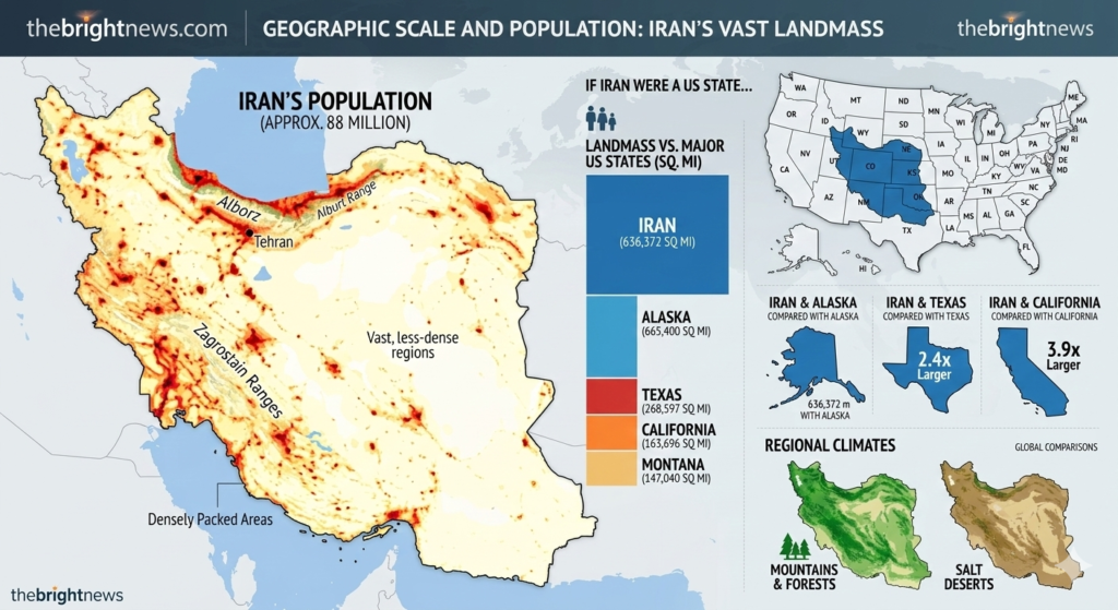
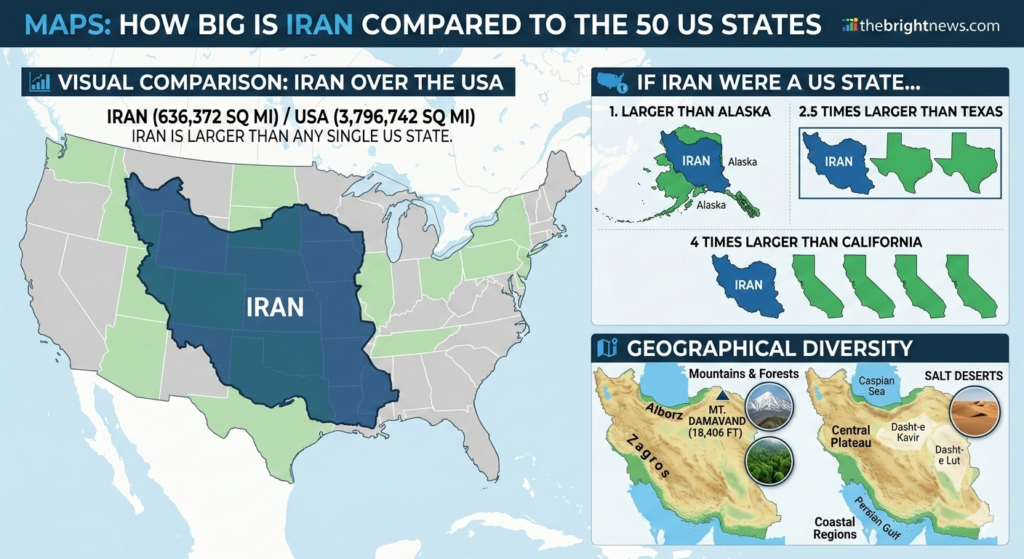
At roughly 636,372 square miles (1.65 million square kilometers), Iran is a geographical titan in Western Asia. But how does that stack up against the 50 US states?
Iran vs. The United States: The Big PictureIf you were to place Iran inside the borders of the United States, it would cover approximately one-sixth of the total US land area.
While the United States as a whole is about six times larger than Iran, the comparison becomes fascinating when you look at individual states.
If Iran Were a US StateIf Iran were suddenly integrated into the US as a state, it would immediately become the largest state in the union.Bigger than Alaska: Iran is slightly larger than Alaska, which is currently the largest US state at approximately 570,641 square miles.2.5 Times the Size of Texas: Texas is famous for its “everything is bigger” mantra, but Iran is nearly two and a half times larger than the Lone Star State.4 Times the Size of California: You could fit four Californias inside the borders of Iran with room to spare.
Visualizing the FootprintImagine laying a map of Iran over the Eastern United States.
Its borders would stretch all the way from the tip of Maine down to Georgia, and reach as far west as the Mississippi River.
It effectively covers almost the entire Eastern Seaboard and the Midwest combined.Geography and DiversityMuch like the United States, Iran’s vast size allows for incredible climatic and topographical diversity. It isn’t just one giant desert.
The Mountains: In the north, the Alborz Mountains house Mount Damavand, a volcano higher than any peak in the contiguous United States (reaching 18,406 feet).The Coasts: Iran enjoys massive coastlines along the Caspian Sea to the north and the Persian Gulf and Gulf of Oman to the south.The Heartland: Between the mountain ranges lies the Central Plateau, a high-altitude region featuring salt deserts and fertile oases.

Why Size MattersUnderstanding the scale of Iran is more than just a trivia fact; it provides context for the country’s regional influence and internal logistics. With a population of over 90 million people spread across this vast terrain, the infrastructure, culture, and environmental challenges are as varied as those found across the American continent.The next time you see Iran on a world map, remember that it isn’t just a mid-sized nation—it is a vast territory that rivals the largest stretches of the American landscape.